Offset calibration for a submersible groundwater level sensor
Whether you're monitoring groundwater level to keep an eye on conditions in the ground, groundwater reserves, or for construction purposes, only the correct reference point will give you correct measurements. Since your sensor measures from its own position, you often need to configure an offset to align its readings with a meaningful benchmark.
In this guide, we'll help you configure the offset of your submersible level sensor to suit your application needs. Please note that this guide focuses on sensor offset calibration for the purpose of groundwater level measurement.
The most important question is whether you want to measure your groundwater level relative to ground level, or sea level?
Ground level
Ground level is the height at which the ground ends and the air starts. Whether that's at the peak of a mountain or in the deepest valley. For dewatering purposes, ground level is most often used as a reference (point zero) for groundwater level.
In some other cases where the absolute groundwater level is required, the groundwater level is often measured relative to sea level.

Sea level
If you want to measure in reference to sea level, this becomes your ‘point zero’. In this case, you'll be measuring the distance between sea level and groundwater level.
First and foremost, not all countries use the same value to denote sea level. You can read more about European Ordnance Data here.
The Netherlands: NAP (normaal Amsterdams peil) is the Amsterdam Ordnance Datum. Other countries that use the NAP value for sea level include:
- Germany, their NHN (Normalhöhennull) corresponds to NAP.
- Luxembourg, Norway, Sweden, and Finland also use a value that corresponds to NAP.
The EVRS (European Vertical Reference System) has also been developed based on the Dutch value.
Belgium: TAW (tweede algemene waterpassing) is based on a measurement in Oostende and is 2.33m below NAP.
France: marégraphe de Marseille is based on a measurement in Marseille and is 0.51m below NAP. Switzerland also uses the French system.
England: ODN (Ordnance Datum Newlyn) is based on a measurement in Newlyn.
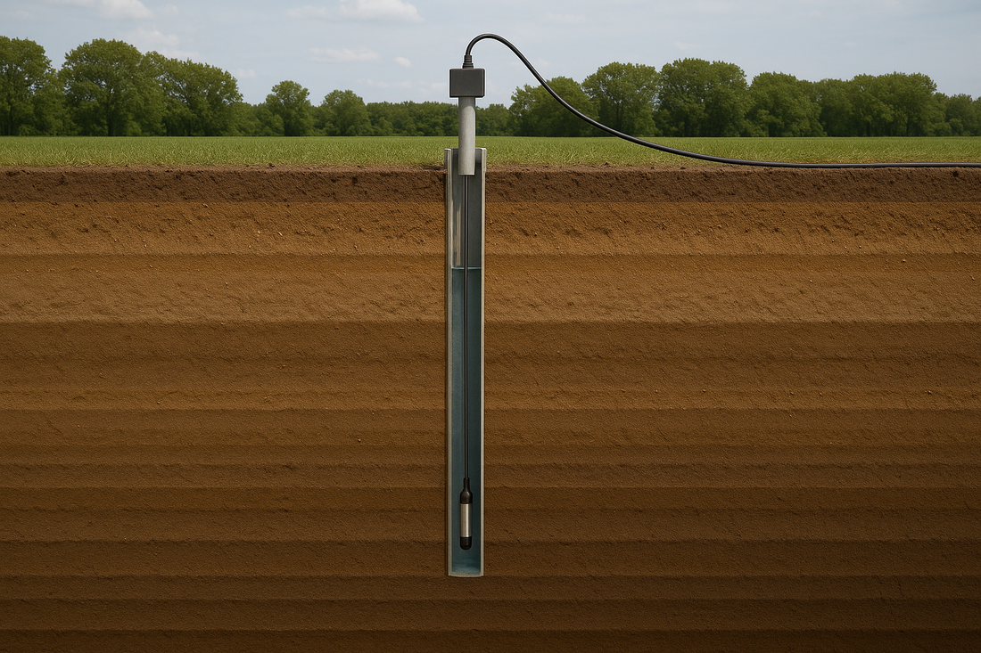
How does a submersible level sensor measure water level?
What exactly does a submersible level sensor measure? A submersible level sensor gives a pressure reading that represents the amount of water in the liquid column directly above it.
Please note that a submersible level sensor accounts for its own height. It starts measuring from its downward tip.

What offset is needed for your application?
In this section, we'll take a closer look at the type of offset that fits your situation.
Steps to follow
- Do you want to measure relative to your local ground level, or relative to sea level?
- For ground level you always start from 0. If you want to measure relative to sea level, you'll have to check what height in sea level your ground level corresponds to, to know your point zero.
- Check the length of your monitoring tube/monitoring well.
- Make distance indications on your pressure level sensor's cable (submersible level sensor), so you know exactly how far from your point zero it is now located. Don't forget to include the length of the measuring probe.
Please note that your submersible level sensor should be able to hang freely in your monitoring tube, hence, your tube should be longer than the length of the inserted sensor cable.
Possible scenarios
To help you understand your own scenario, we'll configure the offset of a submersible level sensor in the Crodeon Dashboard based on the pictures provided.

Our first scenario takes place in the Netherlands, the customer wants to measure relative to ground level. A monitoring tube of 10m was inserted into the ground. Here, ground level = 0m, and the sensor was inserted 7m into the ground. This means that the sensor measures at a height of -7m.
Currently, the sensor measures that there is 1m of water on top of it, making the groundwater level -6m.

Our second scenario takes place in the Belgian Ardennes, the customer wants to measure relative to sea level (TAW). TAW is now our point zero. A monitoring tube of 35m was inserted into the ground. Here, ground level = 400m above sea level, and the sensor was inserted 30m into the ground. This means that the sensor measures at a height of 370m above sea level.
Currently, the sensor measures that there is 10m of water on top of it, making the groundwater level 380m above sea level (or +380m).
Configuring the offset of your submersible level sensor in the Crodeon Dashboard
To configure the offset of your sensor, you'll have to create it in the Crodeon Dashboard.
This offset corresponds to the height of your submersible level sensor: the offset should reflect the distance between the level sensor's tip and the reference point or 0m point. It should be a positive value if the sensor is above the 0m reference point, and a negative value if the sensor is below the 0m reference point. For the first scenario this was -7m, for the second scenario this was +370m.
Please note that whenever you move your sensor, the offset calibration should also be adjusted to the sensor's new position.
Configure Reporter
- Log in to the Crodeon Dashboard. If you do not have an account yet, create one first and claim your Reporter or make sure your account gets added to the right group.
- Select the right Reporter in your group.
- Go to the tab “Configure Reporter”.
- Look for the submersible level sensor and find the channel that indicates water level (distance).

- Click on the three vertical dots in the top right corner of that channel.
- A menu will appear and on the third line (top to bottom) you will see “Offset calibration”.
- Select “Offset calibration”.
- The value should be 0 if this channel hasn't been configured yet. Now change the value to the height of your sensor and click ‘SAVE’.

The first scenario gets an offset of -7, and second scenario gets an offset of 370.


Questions?
Do you still have questions about the offset configuration of your submersible level sensor? Don't hesitate to contact us!